When skies stay cloudy for weeks, stargazing can feel impossible. But a new hobby has opened the skies in a different way—one that doesn’t need clear weather or even nighttime.
Turning Cloudy Nights into Clear Discoveries
Radio astronomy is helping hobbyists explore the universe through invisible signals, and thanks to unencrypted NASA satellite data, anyone can now collect and analyze space-based weather images right from home.
The excitement was sparked by a special satellite called GOES-19. It’s a weather satellite that sits 22,000 miles above the Earth in geostationary orbit. That means it stays fixed above the same spot on Earth all the time. This satellite, launched into full service in April 2025, sends back detailed weather images 24/7—no matter if it’s sunny or cloudy on the ground. What’s surprising is that anyone can pick up these signals using equipment that’s now easy to buy online.
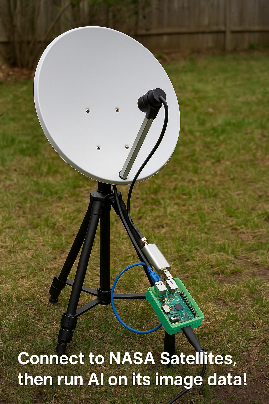
The tools needed include an L-band antenna tuned to around 1.7 GHz, a low-noise amplifier (LNA) to boost the signal, a software-defined radio (SDR) that acts as a signal receiver, and a Raspberry Pi computer for managing everything. Everything connects with standard RF cables, and once the software is installed, the whole system can start pulling live data directly from GOES-19.
With a basic tripod to hold the antenna and a bit of care to protect the electronics from weather, the setup becomes a simple but powerful station. Even without any advanced science background, it’s possible to collect satellite images day and night—right from the backyard.
Moon Goes Nuclear! China-Russia Pact to Build Power Plant by 2036 — No Humans Needed
Real-Time Weather Data Straight from Space
Once the system is up and running, the satellite begins to send stunning real-time images of clouds, storms, and weather patterns. The data comes in the form of high-resolution weather photos that show moisture levels, cloud movement, and temperature patterns. These images are valuable not just for weather watching but also for building custom software tools using artificial intelligence (AI).
After just three days of collecting images, it’s easy to gather enough data to work with AI tools. With about 100 satellite images on hand, the next step is to train a computer model to recognize patterns—like rain clouds—automatically. For this task, a platform like Edge Impulse can be used. It allows anyone to upload images and label them, telling the computer what parts of each image contain the object of interest, in this case, rain clouds.
The labeled images are then used to train an AI model, which learns to detect those clouds on its own. A special method called FOMO (short for “Faster Objects, More Objects”) is used to help the model identify multiple cloud areas in one image. Using a pixel resolution of 320×320 and keeping the images in color (RGB) helps the model distinguish different cloud types based on color intensity—blue, green, or red shades in the image indicate cloud thickness or rain levels.
The training results were highly successful, showing a strong F1 score of 97%. That means the model is very accurate at spotting rain clouds and doesn’t get confused easily. When tested on new images, the model continued to perform well, confirming it had truly learned how to detect the rain clouds.
Bringing AI to Life with a Tiny Computer
Once trained, the AI model can be exported to a special file format and run directly on the Raspberry Pi. This small computer, no bigger than a deck of playing cards, is powerful enough to handle both the satellite data processing and the AI detection tasks.
Using Python code, the model checks each new satellite image for signs of rain clouds. If clouds are detected, the computer saves the image, marks the cloudy areas, and then compiles a group of images into an animated GIF. This animation shows the movement of clouds over time. The animation is then hosted on a small internal web server using Flask, so it can be viewed from any web browser on the home network.
The animated graphic is updated every 30 minutes by a cronjob to keep everything current. This turns the Raspberry Pi into a live satellite weather monitor that runs day and night, rain or shine.
It’s even possible to explore additional types of data from the satellite, including emergency weather alerts and detailed moisture readings. Later, as the system grows, they can be added.
This innovative experiment demonstrates that anyone, with a minimal setup and a little inquisitiveness, can gather real-time data from space and apply AI to analyze it. Artificial intelligence and satellite signals can now be used for educational purposes, entertainment, or even tailored weather alerts.


